Mapping anything with BSicons
If you go to the Wikipedia page for the Forth and Clyde Canal, the Trans-Siberian Railway or the London Circle Line you may notice that they all have route maps with a similar visual style.
How do the many Wikipedia contributors create all these similar-looking maps? The answer is BSicons.
BSicons
BSicons are the building blocks for these route maps. They are an SVG icon set that Wikipedia contributors use to map railways, subways, footpaths, waterways, cycle paths and roads. Any transport system that they want to produce a simplified schematic for.
The icons were first used on the German Wikipedia which is why most of their names are based on German words. ‘BSicons’ comes from the German word Bahnstrecken (Railway Lines).
Each icon has a shorthand name that follows some conventions:
- A Root picks a given icon such as a station or a crossing.
- Prefixes change it’s status, such as if it’s underground or disused.
- Suffixes denote direction and positioning, such as if it curves to the left or is one way.
Here are some of the icons:

STR
A rail line
Root: STR → STReke (line)
WASSER
A river or other waterway
Root: WASSER (water)
KRZu
Two rail lines crossing with one going under the other
Root: KRZ → KReuZung (crossing)Suffix: u → unter (under)

STR+l
A rail line that comes from the left
Root: STR → STReke (line)Suffix: +l → + (from), links (left)
Directions are relative to the line (which is drawn from top to bottom) rather than the page. This is why the suffix says the line is from the left rather than going to the right.

utkBHF+1
A station on an underground light rail line that comes from the first corner
Root: BHF → BahnHoF (station)Prefix: utk → u-bahn, tunnel, kombination (Compound)
the k denotes that the icon is for drawing compound turns that span four columns of icons.


tSTRa
A rail line that goes into a tunnel
Root: STR → STReke (line) Prefix: t → tunnelSuffix: a → anfang (start)

mhKRZho
An elevated rail line going over a light elevated rail line
Root: KRZ → KReuZung (crossing)Prefix: mh → mischbetrieb (mixed), hochbahn (high level/elevated)
Suffix: ho → hochbahn (high level/elevated), overpass
These are a few examples. The BSicon Catalogue explains many more conventions.
Building maps
To help put all these icons together into a map Wikipedia has a Routemap template. The template defines a syntax to provide shortcuts to build maps.
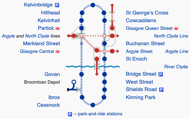
Here is the code used to generate the single highlighted row:
{{Subway|Hillhead}}! !\utkBHF+1\\\utkBHF+4\tSTRa~~{{Subway|St George's Cross}}
The syntax is a bit cryptic and uses the shorthand icons names we saw above. Here is what each part does:
{{Subway|Hillhead}}is a link to the Wkipedia article about this station! !separates the text on the left from the icons\utkBHF+1is the first icon a light rail station in a tunnel that curves\\adds in two empty icon-sized spaces\utkBHF+4adds in the second icon, similar to the last but towards top-left corner\tSTRaadds in the third icon, a start of a stretch of tunnel~~~separates the icons from the text on the right{{Subway|St George's Cross}}a link to the Wikipedia article about this station.
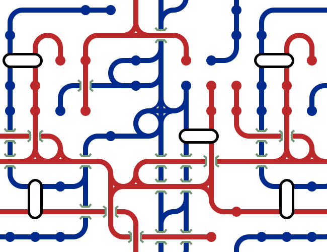
Hundreds of thousands of icons
There are more than 290,000 BSicons out there due to an explosive number of combinations needed for different colours, rotations, intersections, bridges, curves, embankments and tunnels. Many obscure BSicons might only be used a few times across Wikipedia (like BHFABZgl+l)2.
Each icon is simple, so simple many of them are marked as ineligible for copyright on Wikipedia. Together the icons can combine to map more complex systems. Seeing how these icons can be combined inspired me to make a random BSicon map generator.
-
The use of r for roundabout clashes with the use of r for right that's used with other root icons. If you want a road goes to the right you need to use rf (right forward) instead. While many prefixes and suffixes work the same way across multiple roots it's not a perfect system.
-
This icon is used to represent triangular railway stations such as Shipley. There are only two of these stations in the UK.
You can read more by me, follow me on Mastodon or subscribe.

I've just published my book - Build a Database Server. Learn how real databases like PostgreSQL and MySQL work by building your own database from scratch.
Find out more and see a preview.